 odyvero
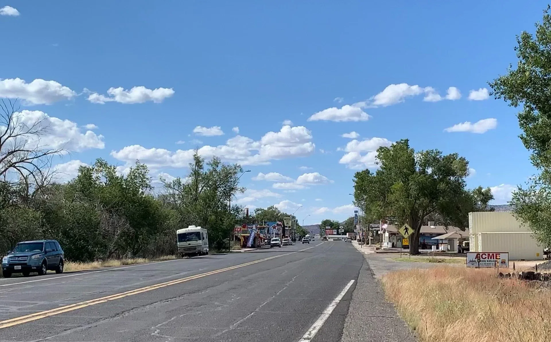
In Seligman, Route 66 still runs along a street lined with small businesses, motels, and display cars. After the 2026 centennial, Arizona offers a compact trip that leaves time to stop. Here is a week-long itinerary from Holbrook to the Colorado River, with the confirmed dates for the 2027 Fun Run and the transportation, overnight, and sightseeing choices that can really shape the trip.
Travel after the centennial
Route 66 turns 100 in 2026: the Historic Route 66 Association of Arizona marks November 11 as the anniversary of its creation. Centennial events are spread across the year and several states. By late October, planning a departure for the following spring calls for a different calendar. Arizona’s Fun Run has already announced its April 30 to May 2, 2027 edition, between Seligman and Topock. This event gives a trip a concrete anchor without artificially extending all the 2026 celebrations.
The historic national route runs from Chicago to Santa Monica for about 3,940 kilometers. A full crossing involves weeks of driving, often a one-way rental, and constant choices between sightseeing and covering miles. For a first week-long trip on the road, we recommend Arizona. It offers urban districts, roadside businesses, plateau scenery, high-elevation forests, and a drive through the Black Mountains. The scenery changes enough to give the journey variety.
The proposed route runs east to west, from Holbrook toward Topock, with stops in Winslow, Flagstaff, Williams, Seligman, and Kingman. Seven days here means time spent on the itinerary, excluding international flights and long airport transfers. The event requires an additional adjustment if you want to take part over several days. The durations shown are editorial planning choices: they help distribute sightseeing, but do not guarantee travel times.
Arizona’s historic alignments
The association lists about 250 miles of Route 66 that are still drivable in the state, or around 400 kilometers. This figure does not represent the total distance of your rental-car trip. Airport connections, access to accommodations, detours, and return journeys add to it. The road has had several alignments; some sections run through towns, while others connect via Interstate 40. A route planner set to the fastest route will naturally favor the interstate.
Planning means identifying the sections that interest you and their entrances, then connecting them in the right order. An offline map with saved stops means you do not have to search for every business from the roadside. Between Seligman and Kingman, the historic route takes you through small communities and makes room for stops. Between Kingman and Oatman, the drive becomes winding. These two stretches call for different kinds of attention and are best separated by an overnight stay.
A heritage perspective also enriches the stops. The National Park Service lists more than 250 Route 66 buildings, bridges, alignments, and other sites on the National Register of Historic Places. Behind the old gas pumps are changes in traffic patterns, family businesses, and towns bypassed by the highway. In Seligman, the movement launched around Angel Delgadillo in 1987 helps explain why so many travelers still return to these businesses today.
Seasons between the plateau and the desert
For this itinerary, April and May, followed by September and October, are the periods to consider first. This recommendation concerns planning a trip across several elevations; it is not a weather forecast. Flagstaff and Williams are in the high country, while the western part of the route descends into desert areas. You need to be prepared to go from a cold morning to a much warmer afternoon without relying on a single piece of clothing.
In spring, a warm layer and windproof clothing are still useful. If you add the South Rim of the Grand Canyon, the National Park Service notes that snow and freezing conditions can still occur during the shoulder seasons. The image of an Arizona that is uniformly warm does little to prepare you for this detour. In autumn, falling temperatures and shorter days make it advisable to schedule smaller roads and walks before the end of the day.
Summer calls for a different distribution of activities: start early in exposed areas, keep water accessible in the vehicle, and visit indoor sites during the hottest hours. A long day of driving followed by an improvised walk is not suitable for every traveler. In winter, conditions on the plateau may require changes to your plans. Before each leg, check local alerts and AZ511; a reservation made several months in advance tells you nothing about road conditions on the day you travel.
Access points and route direction
The airports in Las Vegas and Phoenix are access points to compare based on your flights and rental agreement. Both are outside the proposed historic route. Be sure to include the connections in your schedule: a week shown between two flights can shrink considerably once you account for arrival, picking up the vehicle, and returning it. After a long-haul flight, spending the first night near your arrival point lets you set off well rested.
The westbound route is especially suitable for a trip arriving in Seligman for the Fun Run Friday, then continuing to Kingman and Oatman for the weekend program. Starting in Las Vegas and traveling in the opposite direction may be more convenient outside the event period. Compare the full loop, including the return to the airport, rather than just the scenic segment. Arrange overnight stays around your entry point and any fixed appointments.
Returning the vehicle in a different city may save you from backtracking, but the quote must include one-way fees and all billable days. The car should also fit your luggage without leaving it visible at every stop. For winding roads, check your vehicle’s capabilities and the rental agreement; choosing a large RV changes parking options and how you handle narrow sections. Travelers who are uncomfortable on these roads can plan a different connection and spend more time in the towns.
Holbrook and Petrified Forest
The first day combines Holbrook with Petrified Forest National Park. This pairing lets you see two aspects of the area’s history: the establishments that served motorists and the landscapes they traveled through. In Holbrook, the Wigwam Motel illustrates commercial architecture designed to catch the eye from a car. Lodgings are active places of business: take photos from an authorized area, without entering a room or disturbing guests.
At Petrified Forest, the park road serves viewpoints and walking trails. Set aside a proper amount of time for your visit rather than making a single stop between two long drives. You can see the colors of the Painted Desert and the petrified wood by getting out of the vehicle in areas open to the public. The site also preserves the memory of an early Route 66 alignment. The visit adds geographical depth to the trip before the signs of the towns that follow.
Choose walks according to the weather and your fitness level. Check access arrangements and hours with the NPS, independently of any driving audio guide or pass purchased for another attraction. An overnight stay in Holbrook avoids combining the park, exploring the town, and driving to Flagstaff all in one day. If you have to reach Holbrook from the airport that day, spread these visits over an extra day.
Winslow, then the streets of Flagstaff
The second day follows the corridor toward Winslow. Standin’ on the Corner Park connects a public space with the song “Take It Easy,” while La Posada recalls the railroad’s role in the region’s tourism development. The two stops complement each other: one is a photo stop tied to popular culture, the other a building and its spaces to explore subject to access conditions. Lunch can fit into the Winslow stop before continuing to Flagstaff.
Jack Rabbit Trading Post, near Joseph City, is another possible stop along this stretch. Its sign and rabbit figure show how businesses caught travelers’ attention. Keep the number of stops reasonable: every detour, parking maneuver, and break takes time, even when a photo takes only a few minutes. Arriving in Flagstaff in the late afternoon leaves time for an initial walk without making the whole day depend on the last light.
The third day is spent in Flagstaff. The downtown and Southside areas let you explore Route 66 on foot: the station, former roadside lodgings, façades, and murals are part of a living city. To explore further, the cultural tour offered on Viator lasts two hours, with an English-speaking guide and a departure from Heritage Square. It covers two historic alignments and makes a good break from driving in the middle of your stay. Availability for your date should be checked when booking.
A second night in Flagstaff gives you the option of choosing an additional activity, such as Lowell Observatory, depending on its program, or simply having a free afternoon. This time without changing hotels also makes it easier to shop, do laundry, or rest. On a road trip, it is worth planning for these practical needs rather than pushing dinner later every evening.

Viator
Walking Route 66 in Flagstaff
To understand the two historic alignments and Southside without getting back in the car, set aside two hours, starting at Heritage Square. The guide speaks in English; schedule this walk during your full day in Flagstaff.
- 2 h
- 4.8/5 (33 reviews)
English-language guided walk through downtown and Southside, starting at Heritage Square.
Cancellation policy
For a full refund, cancel at least 24 hours before the scheduled departure date.
From $35.00
View activityWilliams and the Grand Canyon detour
The fourth day takes you to Williams, another Route 66 town where you can walk along the shopping streets before getting back behind the wheel. A program focused on road heritage can devote the day to Williams, then continue gradually to Seligman. The trip retains its coherence: the visits complement one another, and the evenings remain available for exploring each stop.
The Grand Canyon is a separate detour from this area. If it is a priority, add a day and, preferably, a night suited to your plans. The approach, park entrance, travel along the rim, and stops at viewpoints take more time than a break between two towns. For a first visit, focus on a small number of areas rather than rushing through a succession of viewpoints.
Check the park budget, any access arrangements, and road conditions separately. In spring, also check the weather for the rim you plan to visit. A trip built around the Fun Run benefits from having some leeway before Friday: keeping a detour despite unfavorable weather could otherwise make you miss your Seligman appointment. Decide on this extra day before finalizing your weekend accommodations.
Seligman and the road to Hackberry
Day five puts Seligman at the center of the trip. The village offers a glimpse into the history of the road’s preservation, particularly through Angel Delgadillo’s former barber business and the family shop. The stop makes more sense when you connect the storefronts to the association’s founding in 1987 and the return of visitors after the highway bypass was built. A walk lets you look around the businesses without making multiple car trips.
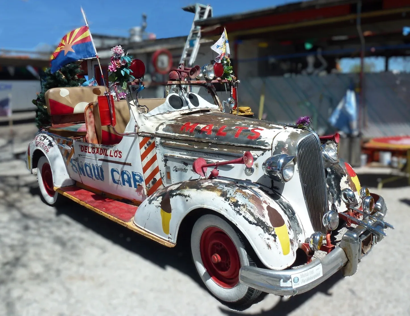
The Snow Cap and its decorated objects are part of this culture of roadside establishments. The photograph of the Chevrolet shown in this article depicts a display at the business, not a vehicle identified as taking part in the Fun Run. When stopping for lunch or photos, keep entrances clear and respect parking spaces. During a gathering, allow extra time to get around and find a spot.
The historic continuation toward Kingman passes through the Peach Springs and Hackberry area. Plan your stops around actual opening hours. Hackberry General Store preserves old pumps and cars, but no longer sells fuel: plan to fill up at an operating station. This detail changes how you prepare for a leg where displays of automotive history can give the misleading impression that services are still available.
To accompany this self-guided section, Action Tour Guide’s Route 66 Arizona GPS audio guide offers commentary in English, downloaded before departure. One purchase covers the passengers in a single car and uses your own vehicle. The supplier lists the experience as lasting five to seven hours; our week includes towns, overnight stays, and additional visits. Attraction admission, parking, and meals are paid for separately. A passenger can manage the app while the driver focuses on the road.


Viator
Arizona Route 66 road-trip audio guide
To accompany a self-guided drive across Arizona with commentary in English. Download the content before setting off; one purchase covers the passengers in your car. Admission is booked separately, and this product does not include the Fun Run.
- 5 to 7 h
- 5/5 (1 reviews)
English GPS-triggered commentary in your own car, to download before departure; purchase is per vehicle, admission fees are separate.
Cancellation policy
For a full refund, cancel at least 24 hours before the scheduled departure date.
From $24.99
View activityKingman, Oatman, and the Colorado River
Day six leaves time to explore Kingman. The Powerhouse area and the Arizona Route 66 Museum offer a way to explore the history of travel before taking a walk downtown. Check the museum’s hours and access information for your visit. Staying overnight in Kingman also serves a practical purpose: it sets you up to cross the Black Mountains in daylight, without having to reach Oatman after a long series of stops.
Day seven follows the road to Cool Springs, Sitgreaves Pass, and Oatman. The curves make this leg feel slower than the highway stretches. Use designated pullouts to stop; a photo is no reason to block traffic or stand in the roadway. In the event of a closure or adverse conditions, adjust your route using official road information.
Oatman retains wooden sidewalks, shops, and the donkeys that are part of its tourist identity. The animals may wander into the street: slow down and give them space. A walk and a meal can take up a significant part of the day without adding another attraction. The continuation toward Topock reaches the Colorado River, the western end of our Arizona segment. From there, continue to the airport, California, or another stop, allowing for the driving time involved.
2027 Fun Run dates
The Historic Route 66 Association of Arizona has announced that the Fun Run will take place from Friday, April 30, to Sunday, May 2, 2027. The program runs from Seligman to Kingman, then from Oatman to Topock/Golden Shores. It is a road gathering with activities and a car show; consult the association for event arrangements. The Viator tours mentioned in this guide are independent activities and do not provide entry for a vehicle in the Fun Run.
On Friday, packet pickup is scheduled at St. Francis Church in Seligman from noon to 5 p.m. On Saturday, the parade is scheduled to depart Seligman at 9:30 a.m. In Kingman, the Show N Shine is scheduled from 8 a.m. to 4 p.m., with local street closures. On Sunday, the program lists awards in Kingman between 9 and 10 a.m., followed by a 10 a.m. departure toward Oatman and Topock. The route concludes with a community gathering and barbecue.
These times are from the published program and may change. The road generally remains open to other users; the Kingman show entails special local arrangements. If you want to see the cars without entering your vehicle, check the visitor access and parking arrangements for that day. If you plan to participate with a rental car, confirm the event requirements and the rental company’s conditions before paying the registration fee.
Hotels must be booked separately. The organizer recommends looking early in Seligman, then in nearby communities if needed. Ideally, spend Friday night in Seligman or an area compatible with the early start, and Saturday night in Kingman. Sunday can end near the Colorado River or with a connection planned in advance. Allow extra time in the proposed week for the gathering: the show and meetups replace sightseeing hours; they do not fit on top of them.
Budget and bookings
Start by pricing flights, a car, and overnight stays together. Compare rental offers based on the total cost: taxes, selected insurance, any additional-driver fee, age-related charges, one-way fees, and fuel policy. Pay equal attention to deposit requirements and accepted payment methods. An isolated daily rate is of little use when deciding whether to return the vehicle in another city.
For accommodation, compare the room cost and its actual capacity rather than relying on an assumed price per person. Two nights in Flagstaff and one well-placed overnight stop may be more comfortable than seven consecutive changes. During the Fun Run, staying near the starting point or show may justify booking earlier. Review the cancellation terms before making every night dependent on a single itinerary.
Then add fuel, parking, meals, admission, and activities. Estimate fuel based on the full route and the vehicle’s consumption, allowing extra for detours. Amounts in dollars remain subject to exchange rates and payment fees. This guide does not give an artificial average for a week: the same stops can result in very different budgets depending on the car, rooms, and excursions chosen.
Activity listings display the prices, currencies, and reviews available in the central catalogue. Their information does not guarantee availability on a future date. To decide what to prioritize, focus first on what genuinely adds to your understanding of the route: the guided walk in Flagstaff for the chance to talk with a guide, or audio commentary for a self-guided drive. Check separately with the relevant organizers for Fun Run registration, museums, and parks.
Before you hit the road
Before making nonrefundable purchases, check the entry requirements that apply to your nationality and circumstances, then confirm the driving documents required by the rental company. You cannot infer these requirements from the language of an activity listing. Appropriate travel insurance for the United States and a clear understanding of your auto coverage are part of the trip’s financial planning.
On your phone, save your overnight stays, access points for historic sections, and timed visits. Download maps and audio content over a good connection, then make sure they open. A charged battery, a compatible cable, and an accessible copy of your confirmations help reduce last-minute searching. The driver should keep their attention on the road; make itinerary changes while stopped.
Each morning, the day’s plan can come down to a few decisions: road conditions, weather in the areas you’ll cross, the first visit, where to fill up, and your target arrival time. That is enough preparation to leave room for spontaneous stops without making the evening uncertain. The proposed week therefore leaves time for a street, a conversation in a shop, or a museum, while keeping the appointments that inspired the trip.
FAQ
How many days do you need for Route 66 in Arizona?
The historic association recommends at least three days and says a week allows visitors to explore the route in greater depth across the state. Our itinerary allows seven days for the stops between Holbrook and Topock. Add time for flights, airport transfers, and returning the vehicle. The Grand Canyon or several days at the Fun Run require extra time if you want to keep the planned visits.
Can you still drive the entire length of Route 66?
You can follow many historic sections, connected by current roads and highways. The routes have changed, and Route 66 was removed from the US Highway System in 1985. In Arizona, plan the sections you want to travel and their connections rather than relying on a single GPS route. Check for closures at the time of your trip.
Does the Route 66 centennial take place in 2027?
The centennial covers 1926–2026, with the anniversary observed on November 11. The Fun Run, from April 30 to May 2, 2027, is a later edition of an annual Arizona gathering. It offers a reason to travel the following spring, but the dates of 2026 events do not automatically carry over to 2027.
Do you need a classic car to experience the Fun Run?
Visiting the towns and watching the gathering are separate from registering a vehicle. The organizer announces a route that is generally open, with a local closure for the Kingman show. To register your car, check the participation rules. If you have a rental vehicle, also confirm the intended use with the rental company before committing.
Are the recommended activities available in French?
Both selected products offer English: a guide for the two-hour walk in Flagstaff, and audio narration for the self-guided Arizona route. These languages were verified in their supplier listings. Your choice depends on how comfortably you can follow the commentary; review booking details and schedules for your date as well.
Is the Grand Canyon on Route 66?
Visiting the South Rim requires a detour from the Williams or Flagstaff area. It adds driving, park access, and time on site. Plan a dedicated day, or longer if you want to do extensive walking, and check NPS conditions. In spring, cold weather and snow may still affect activities on the Rim.
Does an audio guide booking include the car and admission fees?
The selected audio guide provides downloadable content for use in your own vehicle. The purchase covers the passengers in one car. Rental, attraction admission, parking, and meals are paid separately. Download the route before setting off; offline use depends on this initial preparation, and the phone should be handled while stopped or by a passenger.
Where should you stay during the 2027 Fun Run weekend?
Seligman is the most direct base for Friday’s program and Saturday morning’s start; Kingman is convenient for Saturday’s show and Sunday’s start. Accommodation is separate from registration. If you stay in a nearby town, check your early-morning connection and parking access. Book with cancellation terms that suit your trip.
Sources and checks
Plan your visits and check current conditions.
- History and length of Route 66 in Arizona ↗
Historic Route 66 Association of Arizona · Accessed October 31, 2026
What this source supports
1926–2026 centennial, anniversary on November 11; 2,448 miles nationwide, around 250 miles still drivable in the state; separate alignments, decommissioned in 1985, association founded in 1987. Official recommendation: at least three days and up to a week. Our seven-day itinerary is an original editorial proposal.
- Official 2027 Fun Run schedule ↗
Historic Route 66 Association of Arizona · Accessed October 31, 2026
What this source supports
Confirmed event running April 30 to May 2, 2027. Seligman, Kingman, Oatman, and Topock/Golden Shores; times and Saturday local road closure are based on the published schedule and may change. Registration and lodging are separate; none of this article’s Viator offers includes event registration.
- Route 66 locations in Arizona ↗
Historic Route 66 Association of Arizona · Accessed October 31, 2026
What this source supports
Features and geography of the locations: Petrified Forest, Holbrook, Winslow and La Posada, Flagstaff/Lowell, Williams, Seligman, Hackberry, Kingman, Cool Springs, Oatman, Topock. Hackberry no longer sells fuel. A renovation detail dated November 2026 was excluded because it postdates the editorial cutoff.
- Route 66 heritage ↗
National Park Service · Accessed October 31, 2026
What this source supports
More than 250 Route 66 sites listed on the National Register of Historic Places. Heritage context for buildings, bridges, and road alignments.
- Planning a visit to Petrified Forest National Park ↗
National Park Service · Accessed October 31, 2026
What this source supports
Official planning information and access to current conditions. No future prices or hours have been invented; the park visit is independent of the audio offers.
- Weather and elevation at the Grand Canyon ↗
National Park Service · Accessed October 31, 2026
What this source supports
Climate differences due to elevation; snow and frost are possible on the rims during transitional seasons. The recommended months are an editorial choice, not a weather forecast.
- Arizona road conditions ↗
Arizona Department of Transportation · Accessed October 31, 2026
What this source supports
Official service to check for roadworks and closures before departure. No opening is guaranteed for any date in 2027.
- The Route 66 national centennial ↗
Route 66 Centennial Commission / Route 66 Road Ahead Partnership · Accessed October 31, 2026
What this source supports
Celebrations spread throughout 2026 across several states; no assumption that the 2026 schedule will continue in 2027.
- Walking Route 66 in Flagstaff ↗
Viator / operator · Accessed October 31, 2026
What this source supports
Exact ACTIVE product reviewed via Partner API Basic: duration, English language, and logistics. Featured offer with a deep Odyvero affiliate URL provided by our API; exact supplier image and hydrated commercial data. A commission may be earned on a booking; no availability for 2027 is guaranteed.
- Route 66 Arizona driving audio guide ↗
Viator / operator · Accessed October 31, 2026
What this source supports
Exact ACTIVE product reviewed via Partner API Basic: duration, English language, and logistics. Featured offer with a deep Odyvero affiliate URL provided by our API; exact supplier image and hydrated commercial data. A commission may be earned on a booking; no availability for 2027 is guaranteed.
- A vintage Chevrolet decorated with pennants and horns in front of the Snow Cap in Seligman. ↗
Pierre André Leclercq / Wikimedia Commons — CC BY-SA 4.0 · Accessed October 31, 2026
What this source supports
CC BY-SA 4.0; resized and converted to WebP without upscaling. Derivative licensed under CC BY-SA 4.0. Decoded original dimensions [3774, 2913]; derivative dimensions without upscaling [1440, 1111]. Visual check of the originals completed. Scenes in Seligman, not attributed to a specific Fun Run edition.
- Route 66 runs through Seligman between the shops and trees. ↗
APK / Wikimedia Commons — CC BY-SA 4.0 · Accessed October 31, 2026
What this source supports
CC BY-SA 4.0; resized and converted to WebP without upscaling. Derivative licensed under CC BY-SA 4.0. Decoded original dimensions [1920, 1192]; derivative dimensions without upscaling [1920, 1192]. Visual check of the originals completed. Scenes in Seligman, not attributed to a specific Fun Run edition.
Viator — activity pages
Source for the activity information below.Affiliate links: Odyvero may earn a commission when you book through this article’s buttons.
- Walking Route 66 in Flagstaff ↗
Accessed November 1, 2026
- Arizona Route 66 road-trip audio guide ↗
Accessed November 1, 2026


